Tag Archives: geology

Western survivors

On my first western trip, I visited Moab in July. We went hiking in 105 degree heat, the sun pounding the ground and anything above it. We learned to respect the desert, because the desert will win.

I always stop and admire the brave stalwarts of the desert—that scraggly tree growing from a forbidding rock face or that little flower, full of color if only briefly. They can never move. They survive or die.

In an ancient landscape shaped by wind and water on continents that no longer exist, the desert plants are ephemeral. Like the ruins of the southwest and our cities, the landscape will outlast them. But they, like us, can be beautiful for their time.

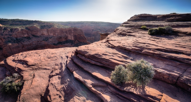
170413-canyon-de-chelly-2241_HDR

Scrub at Canyon de Chelly National Monument

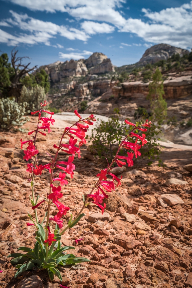
170415-golden-throne-2976

Wildflower in Capitol Reef National Park

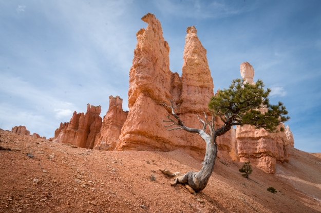
170417-bryce-4018

A lone tree at Bryce Canyon National Park

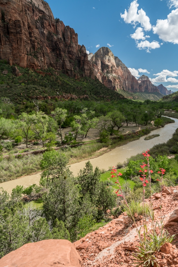
170418-kayenta-trail-4444

Wildflower at Zion National Park

Writing prompt: Old rock day

(It’s the new year and I going to restart my weekly prompts! Hooray! I slacked a bit this fall, which means I’m chock full of inspiration, right?)

Time: 10 minutes plus a 5 minute edit. Click here to go to my list of prompts.

“Old rock day” (Inspired by this list of silly holidays.)

After I went to an exhibit on Mars rocks, I was determined to find my own chunk of Mars. I dropped $1500 on a Pocket Geology GC™ Field Testing Kit. The Pocket GC could vaporize a small chunk of rock and run it through a tiny analyzer. Based upon the composition and structure, it could access an online database and tell you how the rock formed, where it was from, and how old it was. Crowd sourcing meant better data every day. If you really needed to be sure, you could send it off for authentic geological testing by certified scientists… for a price.

Only a handful of Mars rocks have ever been found because most rocks just look like rocks. Peering into their history isn’t something human eyes were made for. But since the Pocket GC hit market, the number of samples had grown by 50%.

I drove throughout the southwest. I studied the circumstances of other rock finds. I kept looking. I kept failing, but I was keeping busy, which is important, right?

I found it, appropriately enough, in City of Rocks State Park in New Mexico. It wasn’t a Mars rock; it was something else. I only went there for the scenery; the rocks there are way too young to find a Mars rock. But, so accustomed to fiddling with my hands, I tested an unassuming chunk of rock.

“Origins: Unknown, age: unknown,” my phone displayed, followed by a mess of chemical data. The Pocket GC didn’t return “unknown” too often these days. Sometimes scientists in the lab with new substances stumped it, but after 5 years of crowd supplied data, it had seen almost everything. So I had found something wonderful: a puzzle. I knew I should send it in for the extra testing. But I decided to keep it intact for a few days as a trophy. It was almost a compulsion, I couldn’t stand to hurt it more than I already had for the testing.

I set the rock on the bedside table as I went to bed that night. In the morning, I woke tired. The dreams crept up on me slowly over the next few nights.

National Monuments in New Mexico

Of the 117 designated national monuments in the United States, 14 of them are in New Mexico, second only to Arizona.  When I moved here in June, I dreamt of Arches National Park and the Grand Canyon and the mountains of Colorado. But I am learning what wonders my own state contains. All are 5 hours or less from Albuquerque, and 8 of them are among the 20 least visited national monuments in the country.

The national monuments here vary wildly. There’s anthropology at the Gila Cliff Dwellings in the mountainous southwest (discovered by a man shirking jury duty). There’s a 17th century Spanish Mission at Salinas Pueblo Missions in the eastern grasslands. There are miles of white gypsum dunes at White Sands, which also doubles as a bombing range.  There’s Petroglyph National Monument on the west of Albuquerque, with canyons full of ancient drawings.

The western landscape expands your vocabulary. You can see a slot canyon and hoodoos, or oddly-shaped rock columns 75 feet in height, at Kasha-Katuwe Tent Rocks. In addition to the lava fields and caves of El Malpais, you can check out the tinajas, dents that hold water after rain and bloom sporadically with life, in the sandstone bluffs. Anywhere you find sandstone you might find tafoni, or small and intricate erosion patterns.

So I’m slowing traveling to the national monuments of New Mexico, camera in hand. I’ve visited Petroglyphs, Kasha-Katuwe Tent Rocks, and El Malpais.

Kasha-Katuwe Tent Rocks

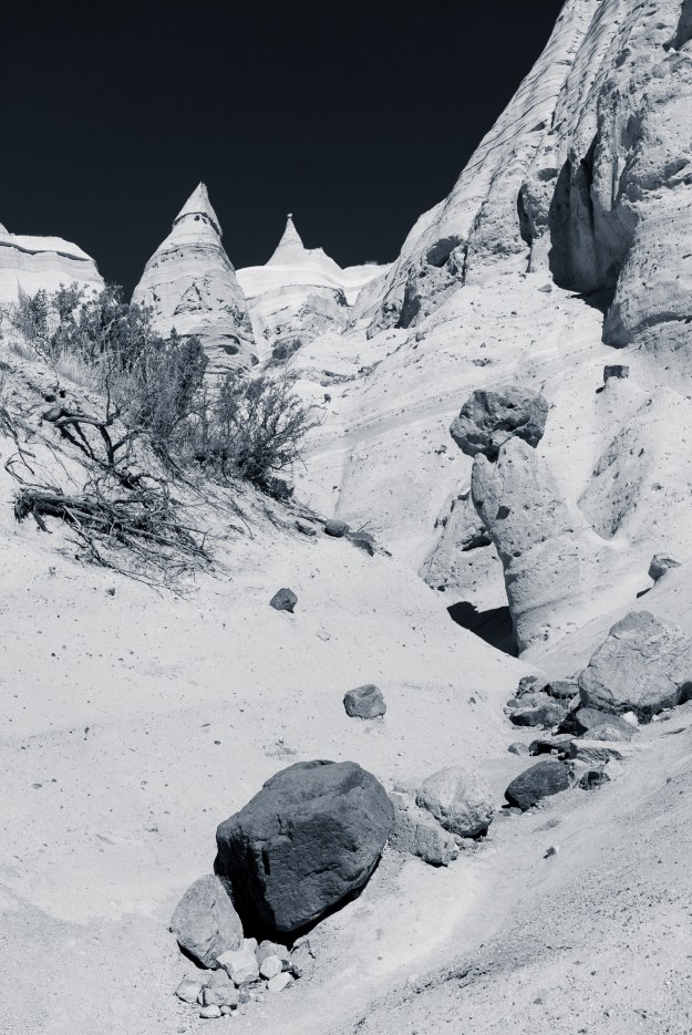
Tent Rocks is named for its rocks that resemble tents, which tower 75 feet. The excellent “slot canyon trail” takes you through a slot canyon, by the hoodoos, and to a viewpoint overlooking the hoodoos; the viewpoint also provides panoramas of New Mexico scrub and the Valles Caldera. The other trail, the Cave Loop Trail, is an easy enough walk but not very interesting. Tent Rocks is a fairly small and recently established national monument. It’s easy to reach from Albuquerque and Santa Fe, with good quality roads.

If you visit Tent Rocks in the summer, get there early. We went in July and arrived at 9 AM and it was hot at the end. Other than the summer heat and rain, Tent Rocks is a great year-round destination. It is fairly popular and gets bus tours on summer weekends.
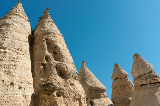
Kasha-Katuwe Tent Rocks National Monument in New Mexico, near Albuquerque and Santa Fe.

Sandstone hoodoos in Kasha-Katuwe Tent Rocks National Monument.
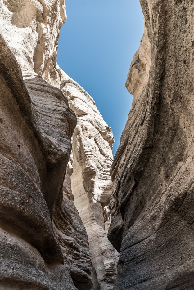
Kasha-Katuwe Tent Rocks National Monument in New Mexico, near Albuquerque and Santa Fe.

Slot canyon.

Kasha-Katuwe Tent Rocks National Monument in New Mexico, near Albuquerque and Santa Fe.

Kasha-Katuwe Tent Rocks National Monument in New Mexico, near Albuquerque and Santa Fe.

El Malpais National Monument

El Malpais translates to “the bad country.” The park has two branches which follow lava fields, which you can see easily on the satellite image of the park. Highway 117 traces the eastern edge and features sandstone bluffs, the second-largest natural arch in New Mexico, and lava fields. Highway 53 traces the west and features volcanic caves and ice caves, although many of the best features are reached only by dirt road. This weekend, I visited the sights along highway 117.

The Sandstone Bluffs Overlook area is great. The light and bright sandstone really stands out against the black fields of lava below. To the north, you can see Mt. Taylor, an inactive volcano. Dents in the sandstone, tinajas, are common on the bluff tops. Though it hadn’t rained much before we went, some still contained water and one had ice at midday.

La Ventana arch, just off the road, is the next stop south. This time of year, the north-facing arch seemed to be in shadow all day. I plan to visit again in April or May, when the light might be better but before the crushing summer heat.

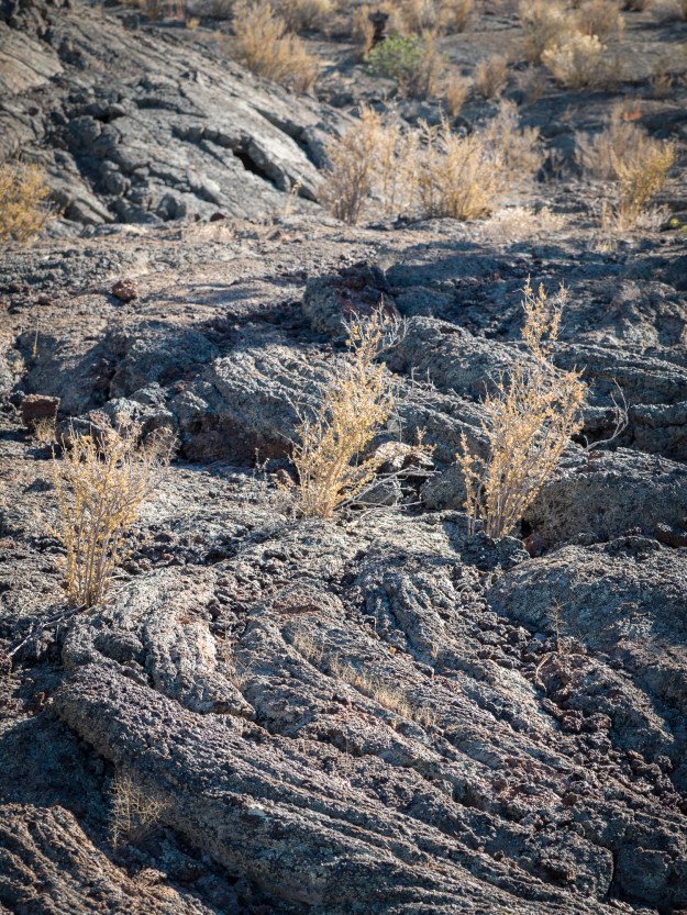
The last stop south is the Lava Falls Area, which features a 1 mile hike through Pahoehoe lava. This is smoother and easier underfoot than most of the lava in the park. The Lava Falls Area is only 3000 years old, extremely young in geological terms, and some of the youngest lava in the lower 48.

In mid November, crowds were no issue. We went on a nice November day and were quite comfortable, even with the altitude. In the Lava Falls Area, it was bordering on warm, with all that black stone everywhere. I suspect much of El Malpais would be unbearably hot in the summer. The dirt roads in the western part of the park are impassable with snow, so the best seasons for El Malpais are fall and late spring.

"A tinaja is a bedrock depression that fills with water during the summer monsoonal rains and when snowfall accumulates in the winter. These microhabitats spring to life when the baked-dry stone basins fill with seasonal water." -From the National Park Service El Malpais website. Sandstone Bluffs Overlook in El Malpais National Monument in western New Mexico.

A tinaja in the sandstone bluffs, looking north to Mount Taylor. Below to the left are the lava fields.

Sandstone formations at Sandstone Bluffs Overlook in El Malpais

Lava Falls Area at El Malpais National Monument in western New Mexico.

Lava Falls Area at El Malpais National Monument in western New Mexico. The lava here has several textures, but my favorite is this ropy, viscous one.

Petroglyph National Monument

Petroglyph National Monument is on the west side of Albuquerque. I realize only now that I didn’t bring my DSLR camera on this trip, but the picture below shows even a cell phone can capture the petroglyphs well. There are three sites in Petroglyph, all easy to reach. The most popular site, Boca Negra, requires some uphill hiking. The two canyons supposedly require less. Like El Malpais, the rock is black and volcanic (though older), and it gets hot in the summer.

In Petroglyphs, you can visit the Three Sisters volcanoes on the western mesa. These three cinder cones are remarkably small, but due to their position atop the mesa are visible from the whole city. Hiking the Three Sisters is still on my to-do list, but I suspect the views back toward the city and the Sandia Mountains are pretty great.

IMG_0837

Petroglyph at Boca Negra site
Writing Prompt: National Tourism Day

Time: 10 minutes. Click here to go to my list of prompts.

“National Tourism Day” (Inspired by this list of silly holidays.)


We met Kosmos at the Spaceport in Richmond. With him (I suppose I really should say it based upon the literature, but it feels rude) travelled a xenobiologist and a diplomat. We were there for local color. I guess we were there to be hillbillies for Kosmos, but everything seemed so different for him I can’t believe he noticed.

When Kosmos came down the jetway, the laughter from his mechanical translator filled the room. The port had been largely emptied, a huge inconvenience, but worth it to host one of the first extraterrestrials. If everyone wasn’t already staring at him, they were now.

“The waves here stand!” he declared to the diplomat, who seemed unfazed. Thomas and I exchanged a glance. I’d once hosted a Tibetan exchange student, and I remembered the culture shocks of her visit. We smiled nervously.

The luxury limo conveyed us west to the mountains. Kosmos had demanded to see mountains.

I had seen Kosmos’ kind on the news often enough, but it was different to experience him in person. The pressure suit hummed softly. Pumps and valves whistled softly at several rhythms. Sometimes, I could see the fluid move through the transparent plates near the top of the suit, where I guessed his face or at least many of his sensory organs must be.

“They tell me you are called Jessica,” Kosmos said, turning his whole body to me in the limo. “And that you are native to this region.”

“Yes,” I replied, feeling a bit out-of-body. “My family has lived in these hills for over ten generations. I’m very proud of it.”

“Hills,” Kosmos breathed in pleasure. “I want to see them all. And caves and cliffs and whatever else you’ve got. This geology of yours fascinates me.”

“I could, uh, show you the fault line down on route 151.”

“Exquisite,” Kosmos said. He turned back to the window.

“His people are aquatic,” the xenobiologist leaned my way. “They live at a depth of 500-1000 meters. He’s very interested in how we live at the boundary of two phases.”

“Of course,” I said. I still wondered what purpose Thomas and I could possibly serve in showing Kosmos around.

Fun Science: Crystals Everywhere!

I went on a trip to DC last fall. Almost accidentally I ended up in the Natural History Smithsonian Museum. Wow! Especially worthy is the section on minerals. I assume there are other museums with such displays, but I hadn’t been to one. The Hope diamond is displayed also in the minerals section, but fancy jewels I can’t touch are way less interesting than all the minerals and natural crystals.

I find crystals fascinating because they tell you so much about the microscopic structure of the material. Where else in life can you just look at an object and see what it does down to the nanometer? So naturally the camera came out. Below are a few favorites, and some comments about what we can infer from the pictures.

IMG_2197

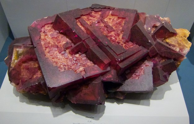
Fluorite (CaF2): As you can see, Fluorite has a cubic crystalline structure. Fluorite can come in basically any color. Color can be due to impurities, exposure to radiation, or defects in the crystalline structure. Fluorite was originally so named due to fluorescent properties; fluorite can fluoresce in a variety of colors depending upon the impurities present.

IMG_2139Beryl (Be3Al2(SiO3)6): You might be more familiar with other names for Beryl, such as aquamarine or emerald or morganite. Beryl is naturally clear, but takes on color in the presence of impurities. Emerald, for example, has chromium or vanadium present. Aquamarine coloration results when the Fe2+ oxidation state is present. Fe3+ results in yellow coloration. You can see in the image above that beryl has a hexagonal crystal structure. You can also see that this is one big hexagonal crystal, unlike the population of cubes in the fluorite picture. This tells us a lot about how the crystal grew. If the crystal grew very fast, there would be a number of columns, because crystallization would be faster than the time for the mineral components to diffuse to one specific column. So this crystal grew pretty slowly.

IMG_2136


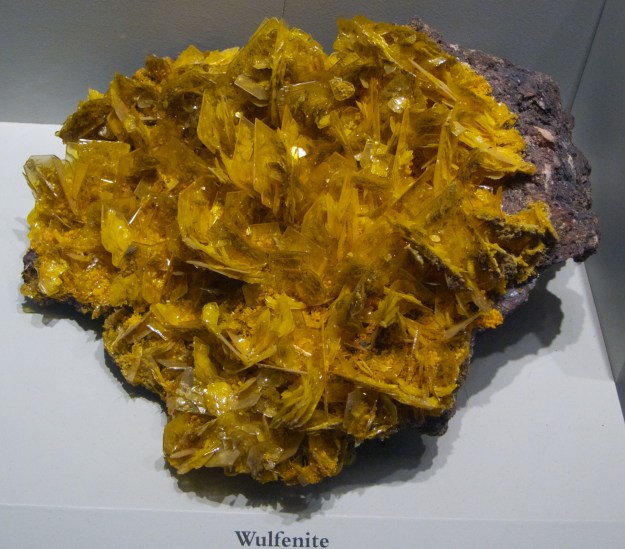
Wulfenite (PbMoO4): Wulfenite is often found around lead deposits, which makes sense since it contains lead. It has a tetragonal crystal structure, and tends to be yellow or orange or brown in color. You can see that the crystals are much smaller in this picture than the beryl crystal. Clearly these crystals grew quickly from many nucleation sites. The size to which crystals tend to grow is a property of the crystal too; some only form a ton of small crystals, some form a few very large ones. It depends whether it is lower energy to just form another crystal, or if it is lower energy to allow diffusion to an already established crystal. This is related to thermodynamics. Wulfenite seems to favor lots of small crystals. Some wulfenite has a really cool property called piezoelectricity; when there is the right kind of pressure on the crystal, an electric charge accumulates.

IMG_2219


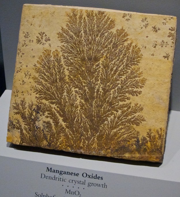
Manganese dioxide (MnO2): This manganese dioxide has grown in a dendritic fashion. It might look like frost or snowflakes, which grow in similar ways. These dendrites are very fractal, a favorite topic of mine. Here diffusion was definitely limited, so crystals grew where the materials were present.

IMG_2174


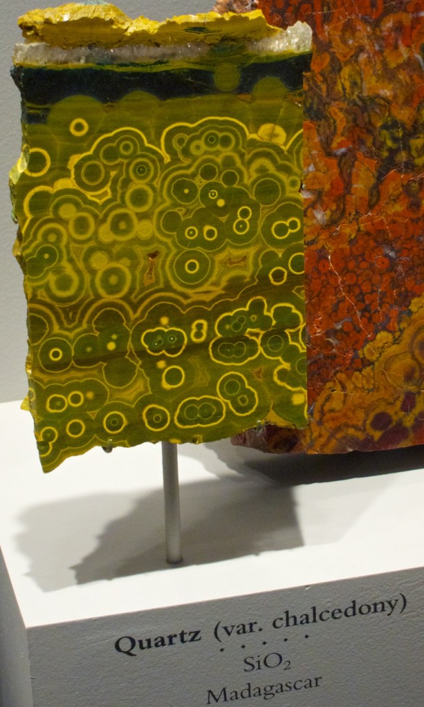
Chalcedony (SiO2): Chalcedony is a type of silicon dioxide, which is the chemical composition of most sand. Chalcedony is composed of two different silicon dioxide minerals: quartz and moganite. Quartz and moganite have different crystalline structures which grow together at a fine scale in chalcedony, which is probably why it looks far less geometric than the other crystals I’ve shown. Agate is a type of chalcedony.