Tag Archives: travel

Beautiful poster books

I love colorblock poster art. My living room is decorated with National Parks travel posters and my bathroom bears WPA hygiene posters (which are available free online from the Library of Congress!). In my guest room, I display JPL’s Exoplanet Travel Bureau posters. What can I say, I have a passion!

So I also collect books of such posters. In recent travels, I’ve found two great specimens!

Intergalactic Travel Bureau Vacation Guide to the Solar System

Great art and great science! Each planet has a poster, and often one or two extras. Each section also has info on atmosphere, year length, and more. Great for kids and adults!

poster books

A few of my favorite illustrations:

This slideshow requires JavaScript.

See America

A collection of posters for National Parks and historic sites, with posters of places like Big Bend National Park and the Jefferson National Expansion Memorial (i.e., the Gateway Arch in St. Louis). Check out the Creative Action Network website, too, which has posters on all kinds of cool topics and projects.

poster books5

This slideshow requires JavaScript.

Advertisement

NM public lands: San Lorenzo Canyon

Of the 121,000 square miles that form New Mexico, roughly 21,000 of them are managed by the Bureau of Land Management. This land gets used a lot of different ways. Some of it is part of national monuments like Tent Rocks or Rio Grande del Norte. Land is leased for grazing, woodcutting, helium production, and oil and gas production. Land is used for hunting and fishing. Western ecologies are fragile and must be managed. Too much grazing and too much plowing lead to broad consequences, as demonstrated by the dust bowl. The BLM manages these uses, working to allow economic use of the lands without exhausting them. When we hiked in Bisti Badlands, we dodged dried cow patties from previous grazing; I was glad we could both use the land.

New Mexico BLM manages several dozen recreation sites, offering rock climbing, mountain biking, hiking, camping, and more. Saturday I visited San Lorenzo Canyon, which is near Socorro. We drove several miles up a wash into a canyon. We enjoyed hiking and a little rock climbing. December hiking in New Mexico can be pretty great. See for yourself!

Some travel whining in lieu of content

Warning! Travel whining!

It’s been a rough Thanksgiving! We spent the holiday in Scottsdale, which was pleasant and sunny, but other aspects of the holiday went awry.

For Thanksgiving dinner, I was overconfident and ate some mousse. I was punished prodigiously for my dairy hubris; it was a rough night. We call it “Karen poisoning.” As you might expect, I am a delight on half a night’s sleep and a forcefully empty tummy. We drove to Sedona, which is beautiful, but has one crowded road in. The next day, we visited the spectacular Musical Instrument Museum in Phoenix.

The drive back to Albuquerque includes some crazy (by my midwestern reckoning) elevation changes; Scottsdale is at 1200 ft and the pass near Payson (climbing the Mogollon Rim) reaches 7700 ft. The Petrified Forest is at 5000 ft, followed by the continental divide at 7200 ft, and Albuquerque is at 5000 ft. In contrast, my home of Missouri ranges from 230 to 1700 feet of elevation.

We hit snow on the pass by Payson. We climbed through white mist as the snow started to stick to the road surrounded by nervous Arizona drivers. After the pass, the sun came out and illuminated a field of windmills. At Petrified Forest, we hit snow again, this time after dark. So, with knowledge that the continental divide would be worse than what we had seen, we stopped in Gallup, New Mexico. In the morning, we made the last, uneventful leg of the trip. It was all over.

This slideshow requires JavaScript.

Yesterday, my husband about exploded with food poisoning. Thankfully, I seem unaffected, since I’m still recovering from my dairy-itis. However, one is only so unaffected in a 900 sqft house. It’s too distracting for writing the blog and the day job, so I decided to bump my post to next week in favor of a little cathartic whining.

Next week post: my review of this book about the Haymarket Affair, a terrorist attack on the Chicago police inspired by labor and class tensions.

Western Skies: Sunsets

After a year in New Mexico, some things grow familiar. Red or green chile goes with everything, in the morning there’s probably a hot air balloon somewhere, and at night I will hear people gunning their engines on Route 66. But the New Mexican sky still amazes me. Whether its the stars at night, the distant rain, or the views of mountains for miles, it’s so different than the skies I have lived under for the rest of my life. In Missouri and Virginia, the sky was overhead. In New Mexico, it wrap around you like a bowl, a massive semi-spherical window into the universe.

This slideshow requires JavaScript.

Western Ghost Towns: St. Elmo, Colorado and Chloride, New Mexico

The west contains amazing variety. You can see lava fieldsslot canyons, and dunes of white sand. There’s 400 years of Spanish history, and thousands of years of native history from multiple cultures. Artifacts in the hills and deserts of the west will stay put for a long time. The Animas River Spill led to coverage of abandoned mines in the west, remnants of the 1880s mining boom. This article at least suggests 150,000 abandoned mines, 4,000 of them uranium mines. On a happier note, many of the old mining settlements survive in some form today.

St. Elmo, Colorado is a beautiful little mountain town with nature and scenery. Its wooden buildings have been preserved very well, and are well-suited to photography.

Chloride, New Mexico, had one of the most excellent and unique museums I have visited. Mr. Edmund at the Pioneer Store Museum has spent decades of his life cleaning and documenting the store and the town history. He gave us a wonderful personal tour for over an hour.

St. Elmo, Colorado

St. Elmo is in a remote valley of central Colorado near the Arkansas River headwaters. We stopped by en-route from Great Sand Dunes National Park to Pike’s Peak. St. Elmo is a quintessential mountain ghost town, with beautiful timber construction, moody skies, and looming snowy mountains. Its population peaked at around 2,000 people. St. Elmo had gold and silver mining (over 150 claims in St. Elmo alone). It was near the Historic Alpine Tunnel, an engineering marvel, built in the 1880s and still the highest rail tunnel in the country. (If you want to see that, that requires some walking.)

When the railroad stopped maintaining the rail line in 1910, the town faded. One family stuck around, and today a lot of buildings survive in lovely condition. St. Elmo has mountain biking, an adorable-looking Bed and Breakfast, ATV trails, and more. Also nearby is Mt. Princeton Hot Springs, which looked inviting.

This slideshow requires JavaScript.

Chloride, New Mexico

How can you not adore a name like Chloride for a mining town? Chloride was named for its silver chloride deposits, and was a silver town. At its peak, it reached a population of 3,000 with 9 saloons. (Today, it has 11 residents.) The town collapsed when President McKinley made gold the monetary standard, and silver prices plummeted. Chloride had 42 mines, a crushing plant, and a smelter.

The general store continued on after the mining bust. In 1923, it was boarded up while the son went east to study. He studied physics and moved to California, so the store sat unmolested (except by bats) for 70 years. It is a time capsule rich with history. You can peruse the signatures in the post office book. The museum manager, who restored the building and its contents himself, will show and tell you about the many fascinating items within the store. There are purchase records, old bottles of whiskey, packages of gum, nails, ladies hats, and even a dynamite detonator.

Today, one mine is still active nearby, mining zeolites, which are cool, but a tale for another time.

This slideshow requires JavaScript.


The National Parks Passport

Since moving west, I’ve had the pleasure of visiting lots of national parks and monuments. I love the hiking, the photography. I love learning about the geology, the flora and fauna, the history, and the archaeology of the parks. But one silly thing brings me a lot of joy: the national parks passport.

The passport is like a travel passport, but stamps are collected at parks rather than airports/countries. After the initial purchase of the book (about $10), the stamps are free. The stamps are generally located by the ranger in the visitor center. The simplest stamps just have the name of the park and the date. Sometimes there are graphic stamps, and this year, most parks have had 100th anniversary stamps for the hundredth anniversary of the National Parks Service.

Until six months ago, I’d never heard of the passport. I felt like I’d missed so many stamps already. Many friends hadn’t heard of the passport either. Now, walking to the ranger station with my passport, sheepish at my childlike delight, is a part of my park ritual. As of this post, I have 38 stamps from 12 national parks and national monuments. It’s a great way to record travel dates, and a terrific hit of silly endorphins. Most of the national park service sites have the stamps, from national seashores to historic forts to national monuments and parks. North Carolina’s lighthouses have stamps, DC’s memorials have stamps, and the St. Louis Arch has a stamp, to name a few examples. If you have a collecting streak and travel to parks sites, the passport might be a great little friend to you.

IMG_2943

The passport is available in national parks gift shops. We leave ours in the armrest of the car, so it’s always ready to go.

IMG_2944

Some southwestern stamps from Gila Cliff Dwellings and Chaco Canyon. Chaco has a graphic stamp, which is exciting!

IMG_2945

You can by regional stickers separately. Confusingly, there is also a Fort Union in New Mexico, but it was not a trading post. There are stamps for hiking trails and heritage areas, as shown above.

Chaco Canyon: New Mexico’s ancient convention center

Chaco Culture National Historic Park is in remote northwest New Mexico. The drive will take you on twenty miles of dirt roads and beyond cell range. But in this most remote reach of New Mexico lies the crossroads of an ancient culture. In Chaco Culture National Historic Park lies 3,614 recorded archaeological sites, including many massive great houses. The largest, Pueblo Bonito,  has roughly 800 rooms; visitors may walk through the doors and rooms of Pueblo Bonito. The Chaco Culture also built astronomical features into many of their works; some windows align perfectly with the sun on solstice, and some decorations align with phases of the moon.

When Chaco was discovered in modernity, it was thought to be a vast city. Having walked through it, it feels that way. It feels like it could hold thousands. But archaeological evidence suggests otherwise—there is little garbage, and few burials. Massive Pueblo Bonito may have housed only 70 people on a permanent basis. The guides at the park suggest that Chaco might have been a meeting ground, used for trade and weddings and astronomical ceremonies for a small portion of the year. Remnants of cacao from 1200 miles south have been found at Pueblo Bonito. The bones of macaws, native to eastern Mexico, have been found at Pueblo del Arroyo. They apparently didn’t flourish; only the bones of adults were found. So the astonishing quantity of ruins at Chaco Culture Park may be the remnants of an ancient convention center.

Chaco offers an amazing range of ruins, from the many-roomed grand houses to petroglyphs to astronomical markers to ancient stairs and roads. Like Mesa Verde National Park, not so far to the north, the whole site was abandoned in the 1300s, well before European influence. Like Mesa Verde, archaeologists don’t know exactly why the people left. There is evidence of an ancient drought. Some argue for catastrophic deforestation after all the building at Chaco (because all that construction took a terrific amount of timber, some of which still remains in the structures), though there is not consensus.

I grew up in St. Louis, a town once called Mound City for the mounds left by the ancient Mississippian culture. The massive city at Cahokia was also abandoned around the year 1300. A city of 15,000 abandoned, around the population of London at the time, and we don’t know why. It’s easy to live in the United States and think of it as the new world. But these amazing works of ancient people live on quietly. The inconvenient mounds of St. Louis were largely destroyed; those who did so may not have even realized their origin. But the remnants of the Pueblo culture at Chaco remain, mostly protected by their isolation over the years. Though the journey today is easier than it ever has been, Chaco is still hours from the interstate and quiet. As I took in the ruins, I was filled with the same wonder and questions that Cahokia Mounds always presented. Places like Chaco and Cahokia are reminders of humanity—no matter the size of the structures we build, one day people will view the barren remnants and wonder about us. We will walk the same valleys and cliffs, touch the same stones, but we won’t know each others names or voices or values. Ruins like Chaco remind of us of our place in the universe, and how beautiful and belittling that can be.


This slideshow requires JavaScript.

This slideshow requires JavaScript.

160611-chaco-canyon-0717

The stars through my tent at Chaco Culture Park. Chaco is one of the night sky parks, where the darkness of the sky is specifically preserved through lighting choices and such. In light of the ancient Pueblo interests in astronomy, it seems appropriate.

160612-chaco-canyon-0877_HDR_1

Sunrise at the camp site.

One year a New Mexican

A year ago this week, I arrived in the Land of Enchantment and called myself a New Mexican. Since then, I’ve seen a lot and learned a lot, much of it I have posted here at this blog. More than I could ever fit into a single post. So instead, I include 24 of the 24,000 pictures I’ve taken since I moved to this lovely state. They are images of architecture, culture, geography, wildlife, weather,industry, and celebration from all around New Mexico.

Happy anniversary to me. New Mexico, I can’t wait to see what you show me in the next year.

This slideshow requires JavaScript.

Surprises out west: Florissant Fossil Beds National Monument

Last week, I traveled through eastern Colorado, hitting Pike’s Peak, Rocky Mountain National Park, and the Great Sand Dunes. But the biggest surprise was a tiny national monument in central Colorado—Florissant Fossil Beds National Monument. Florissant Fossil Beds has provided fossils to the scientific community for over 100 years; an estimated 40,000-50,000 specimens of some 1500 species. As a visitor, you learn about how the fossils at Florissant formed and the era from which they came. The visitor center is full of great science and amazing fossils. A fossil learning lab is open from 1PM to 3PM. The most impressive part, though, are the massive petrified redwood stumps. The largest is 41 feet in circumference and about 10 feet high.

Scientists started coming to Florissant to document fossils in the 1870s. Unfortunately, tourists flocked to the site as well, fascinated by the redwood stumps and petrified wood. Once upon a time, petrified wood littered the landscape. Now, visitors take in the big stumps alone. The biggest stump has two blades still embedded in it, remnant of when someone tried to chop it up to sell pieces out east. Two tourist companies staked out the site and competed bitterly over traffic. One left nails at the other’s entrance; they also literally got into a shooting match.

Federal protection came very late for Florissant. Despite calls for conservation going back at least to the 1890s, it took until the 1969 for the site to gain national monument status. Before that, people wanted to divide the site up for houses. Environmentalists faced down bulldozers. Standing in the empty fields of Florissant, over an hour west of Colorado Springs and really in the middle of nowhere, it was hard to imagine why the area needed more houses. By contrast, Petrified Forest National Park gained National Monument status in 1906. When you visit Arizona’s Petrified Forest, they will tell you how much petrified wood has left the park through tourism—Petrified Forest is still littered with petrified wood while Florissant is not.

I learned a lot about fossils and fossil formation at Florissant Fossil Beds. I marveled at the great tree trunks, wondering how many more must lay still buried around me. But I think I was most struck by the story of conservation at Florissant Fossil Beds. The monument covers the fight to preserve Florissant, but it can’t editorialize. Florissant is a microcosm of when capitalism and general human interest don’t align. Many of our national lands tell the story of where the human interests won. Florissant tells a story where that interest emerged on top at the very last possible moment; I felt wistful wondering how many marvels wandered away with all the care of a tourist buying a souvenir shot glass.

If you find yourself in central Colorado, stop by Florissant for a visit. The stumps are truly other-worldly. I learned a lot about fossils. And I took a pleasant hike through an alpine meadow in the shadow of Pike’s Peak. The park implores us to imagine what the meadow was like 30 million years ago when the valley was in the flow path of a volcano. I also found myself imagining the place as a virgin bed of paleontology 150 years ago.

IMG_2833

41 foot circumference petrified tree stump

IMG_2831

Pike’s Peak!

This slideshow requires JavaScript.


El Morro National Monument

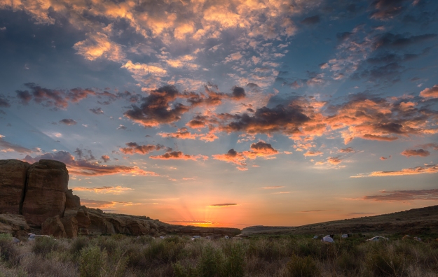
El Morro National Monument is a tiny park tucked in remote western New Mexico. For this reason, it is one of the least visited National Monuments in the west. Ironically, El Morro is a park because it was once a travel hub—a source of year-round drinkable water amongst miles of dry scrub. Over many centuries, visitors came to the oasis and left their mark. Ruins of a 700 year old pueblo sit on the mesa top. Around the base, there are petroglyphs, signatures of conquistadors, and marks of early Americans traveling west. El Morro was scouted for the railroad, but it went 25 miles north. Now El Morro is a quiet place, a sandstone guestbook with centuries of entries.

Don Juan de Oñate

Don Juan de Oñate was the first Spanish colonial governor of New Mexico from 1598 to 1610. He founded the city of Santa Fe in 1610, eleven years before the Pilgrims first Thanksgiving. This carving at El Morro took place on an expedition to the Gulf of California.

Oñate is sometimes called the last conquistador. After the Acoma indians refused to give the Spaniards more food in the winter of 1598, a scuffle erupted that killed 11 Spaniards. Oñate’s retaliation killed 800 Acoma. Oñate enslaved the remaining population; men over 25 had their right foot amputated. Oñate was recalled to Mexico City for cruelty. He resigned his post in 1610 after the founding of Santa Fe. He was banished from New Mexico, although cleared of charges. Acoma Pueblo was rebuilt, and is one of the longest continually occupied places in the country.

Amazingly, people still honor Oñate. El Paso erected a 34 foot statue of him in 2007. Española, New Mexico has an Oñate monument with a bronze statue. In 1998, the 400th anniversary of his arrival in New Mexico, someone removed the statue’s right foot and left the note “fair is fair.” The foot was replaced, but the seam is still visible. Oñate deserves his place in the history books, but multi-million dollar statues seem unnecessary.

Standing in the presence of his carving reminds one of the vast history of New Mexico. The Salinas Pueblo Missions were a generation old at this point, to say nothing of the indian cultures they encountered. We think of the west as new, but this was all before the Pilgrims dined.

160424-el-morro-added-9995

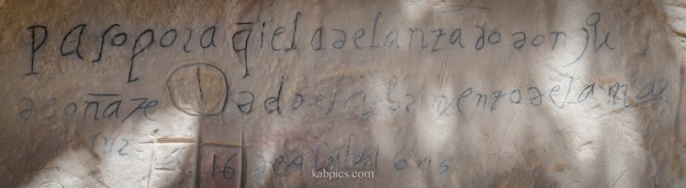
A bit hard to read, but at the end of the first line are the letters “don ju” and at the beginning of the second “de oñate”. This was carved in 1605.
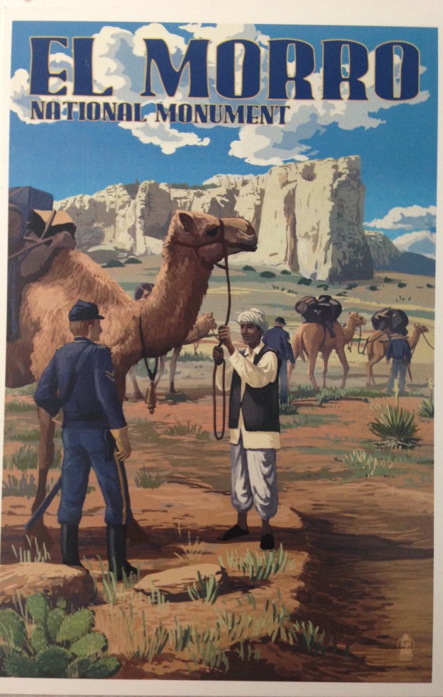
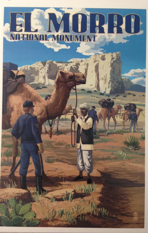
The Camel Corps

In addition to tragedy, the west is full of quirky, charming history, and the US Camel Corps is one of those bits. Desert animals like camels must have seemed ideal for the deserts of New Mexico. 25 camels traveled through El Morro in 1857.

The US gained the territory of New Mexico after the Mexican American War in 1848. (If you ever want an eye-popping historical read, take a look at the list of Mexican heads of state from 1821 to 1848. I thought US history from Jackson to Lincoln was chaotic, but wow. It makes telenovelas look plausible. It’s amazing the US didn’t take more land from Mexico considering the utter disarray of their government.)  Several early expeditions took place, mostly with the goal of figuring out what to do with New Mexico.

The camels went to Camp Verde in Texas, which was taken by the Confederates at the beginning of the Civil War. Some of the animals were sold at auction, some went to zoos, some went to circuses, and some escaped. Camel sightings were reported in the west until the early 1900s. This charming postcard memorializes the Camel Corps’ visit to El Morro.

FullSizeRender 2


The walls of El Morro are full of inscriptions, tiny slices in the lives of people who altered the west, for better and for worse. Though they are just gouges in sandstone, it is humbling to stand and look at the names and know what extraordinary efforts those people took to reach this oasis. And I consider it a bit inconvenient because it’s 2 hours from Albuquerque. We who pass through are still altering the west, though we are warned not to do it by carving El Morro. If you really must, they have a sacrificial chunk of sandstone by the visitor’s center.

This slideshow requires JavaScript.