Monthly Archives: November 2015

The Mineral Maketh the Monument

I spent my holiday weekend exploring New Mexico and Arizona. I visited four national park service sites. I played in the sand, hiked amongst stone columns, walked through fields of trees turned to sparkling stones, and looked from a volcanic plateau over a desert of color. I visited White Sands National Monument, Chiricahua National Monument, Saguaro National Park, and Petrified Forest National Park, and with the exception of Saguaro, I was struck by how little flukes of crystallography and geology birthed the places of beauty I admired.

White Sands National Monument

White Sands National Monument is located in southeast New Mexico, not too far from Roswell. The national monument is surrounded by White Sands Missile Range, which contains the Trinity Site (which by the way, looks rather dull from the road, just a plaque. There were a lot of cattle grazing nearby, amusingly). Occasionally, the monument closes because of tests on the missile range. The morning of the day we visited, an F-16 crashed in the missile range (the pilot was okay).

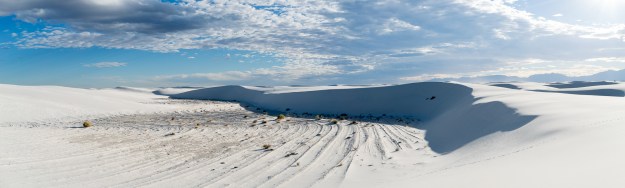
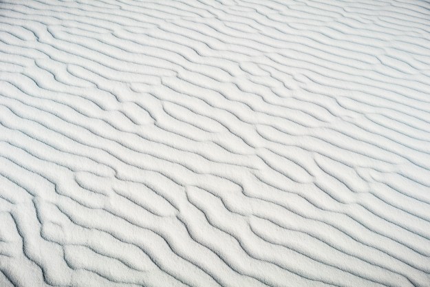
White Sands National Monument is made up of gypsum sand. That sand is actually why it’s a missile range. It’s brilliantly white, and thus makes a great target. Check it out on google earth, it really sticks out.

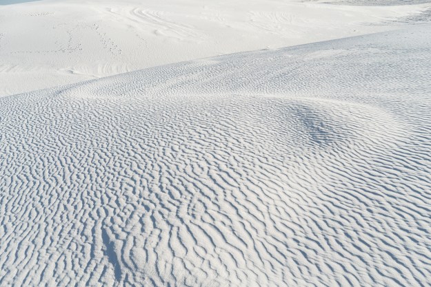
Gypsum is water soluble, so gypsum dunes are pretty rare. The White Sands dunes exist because the Tularosa Basin in which it sits has no drain. The dunes are basically a dried lake bed–a small lake does exist at the southern end of the park. In my humble opinion, gypsum kicks silica’s (normal sand) butt. The grains are very fine. They sell sleds in the gift shop, and families went sledding on the dunes. The sand doesn’t capture heat like silica sand does. And when you get sand in your mouth, as you will when sledding or when you drop your water bottle in  the sand like I did, it dissolves. Truly, the gypsum sand dunes are the closest thing I’ve ever seen to warm snow.

(Gypsum is generally just a cool mineral. Selenite is composed of gypsum. If you’re in a rock shop, find a piece to look at. Selenite has what is known as birefringence–if you set it on text and look through it, you’ll see that text twice. Gypsum also is what desert roses are made of. Selenite crystals have been found up to meters long in caves in Mexico. Gypsum is also what makes drywall. And gypsum is just calcium bonded to sulfate. Chemistry is wonderful stuff.)

The White Sands National Monument is spectacular, more spectacular than many national parks I’ve seen. The nearby Organ Mountains are beautiful too. I suspect this would be a national park, if not for the air force wanting to bomb it from time to time. It is absolutely worth a visit– but it is in southern New Mexico, so perhaps at a cooler time of day or year. On November 25th, it was a high of 75, and it was great.

151125-white-sands-06624-Pano151125-white-sands-06654151125-white-sands-06022

Chiricahua National Monument

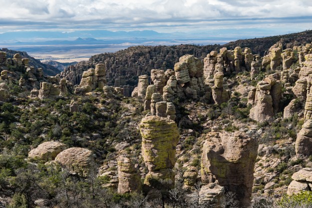
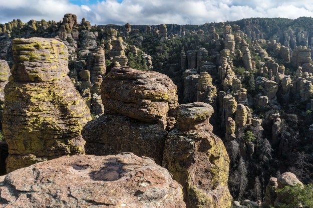
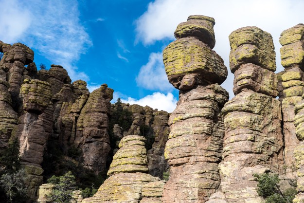
Chiricahua National Monument is the 14th least-visited national monument of the 114 national monuments in the country. I thought it was paradise. There aren’t many places this beautiful that you can enjoy in relative privacy. Unlike many of the little-visited national monuments in New Mexico, Chiricahua has quality paved roads all the way to and into the park. It’s only a 40 minute drive from I-10 in southeastern Arizona. If you happen to find yourself in that part of the country, Chiricahua is worth it.

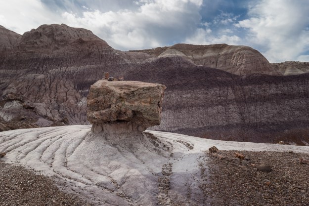
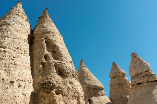
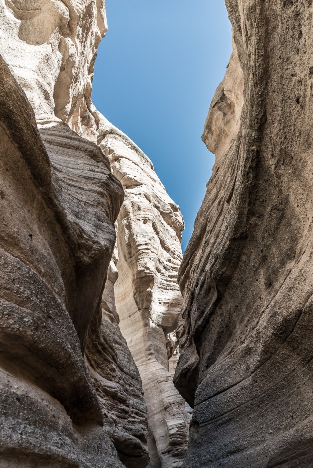
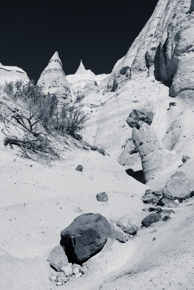
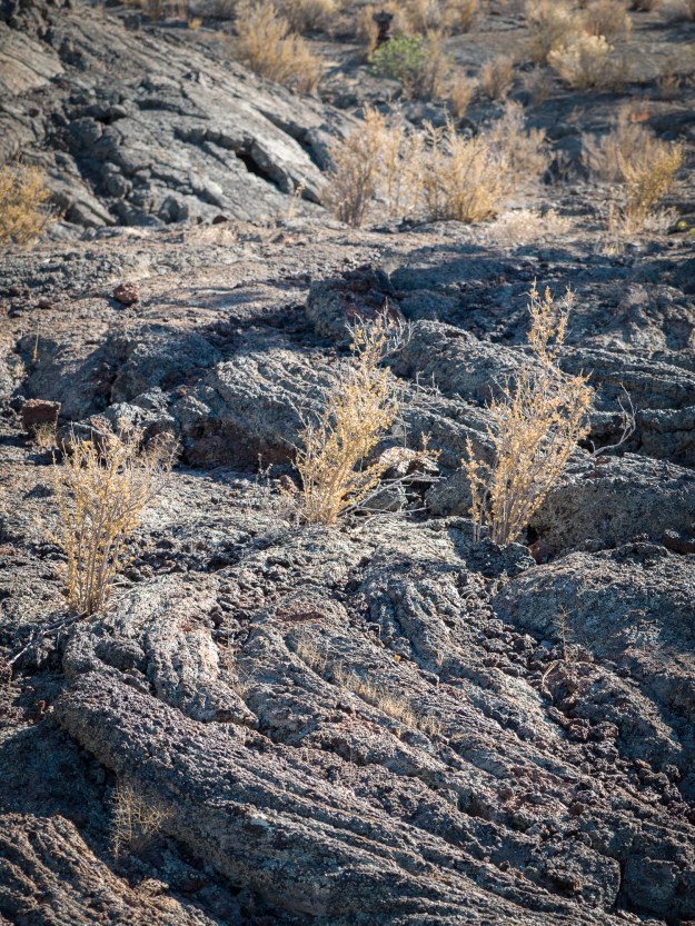
The magic mineral in Chiricahua is volcanic rhyolite. Rhyolite is chemically similar to granite, but it forms differently. It cools faster at the time of formation, and therefore has smaller crystals. The rhyolite at Chiricahua formed with tension in the rock, leading to cracks called joints. Over millions of years, wind, water and plant life have worked at those cracks and led to the thousands of rhyolite pillars that fill the park. Much of the work was done in the CCC era… walking around I marveled at what hard work that much have been in this park, and yet 80 years later the park is still relatively unknown.

Chiricahua has been one of my favorite hikes yet. We did the Echo Canyon loop trail, which is chock full of great sights. You see columns up close and at a distance, with relatively little pain for a 3.3 mile trail. Several other longer trails looked like fun, and I intend to be back to check them out.

151126-chiricahua-07025151126-chiricahua-07153151126-chiricahua-07206

Petrified Forest National Park

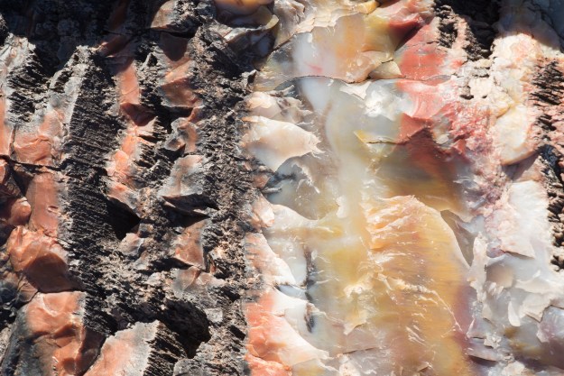
Although this was the most famous of my destinations, the miner0logy for this one was the toughest to research! Petrified Forest National Park contains its eponymous petrified wood, but it’s also famous for the colorful sands of the painted desert. I found lots of information on petrified wood; it is formed by felled trees that, because they get buried for some reason, are not subject to the normal decay processes. The wood turns to agate (like those agate slices from geodes that I used to collect as a kid) and the result is beautiful colors and stone. Some of the wood is imperfectly agatized, and still contains ancient DNA, which is also cool. It’s pretty cool to think that the grassland desert of Petrified Forest was once an equatorial forest full of enormous trees. What a difference 200 million years makes!

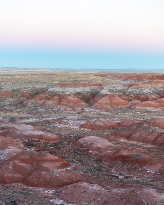
The painted desert was harder to research. The different colors are due to different layers of rock from different eras. But I wanted to know why some were blue or red or purple or yellow! What chemicals? The internet is built by geeks of the bit variety and less the atom variety, so my struggle turned up little in the initial investigation. So, I take it as a great challenge for a future post!

Petrified Forest was a bit cold this time of year! The low overnight when we were there was 22. So I must recommend it with a tad more warmth. But the hiking was great. We did a backwoods trail by the Jasper Forest and walked along the dirt road that once brought stage coaches from the railroad station. If such a landscape feels alien to us, with TV and internet bringing us HD video of any place at a click, one thinks what a landscape felt like in 1906 when the park was designated as a national monument. Even today, it’s an open, austere place, full of ruins 200 million years old.

151128-petrified-forest-08657151129-petrified-forest-08839151128-petrified-forest-08492

Advertisement

A Thousand (non-paper) Cranes

Every year, sandhill cranes migrate south for the winter. They winter in Florida and the gulf coast and California. You might be surprised to hear that they winter in New Mexico. And they do, by the thousands. And one of the places they winter is the Bosque del Apache National Wildlife Refuge, about 90 miles south of Albuquerque.

This past week, Bosque del Apache hosted its annual Festival of the Cranes, a wildlife and photography event focused upon the large wintering population of cranes. The festival hosts classes, workshops, and lots of bird-obsessed topics. We visited the festival on Friday. And we saw a ton of cranes. But we also saw thousands of snow geese, several deer, at least a hundred turkeys, a western screech owl, and several raptors.

Our guides told us that the refuge was established in 1939. Canals and ponds were constructed with CCC labor. In the first year that records are available, 1941, the refuge hosted 19 cranes. Nowadays, the estimates run closer to 20,000. It is not something I expected to find in New Mexico. At sunset, we watched hundreds of them glide in to land, and we watched the somewhat-territorial birds squawk at each other and vie for space. It’s truly a wildlife experience that can be had with little expertise and little hiking. The cranes are around until February this winter and every winter. I know I’ll be back.

151120-festival-of-cranes-05727

Cranes landing at sunset in Bosque del Apache National Wildlife Refuge in New Mexico.

151120-festival-of-cranes-05652

151120-festival-of-cranes-05791

Territorial negotiations amongst cranes. The ones with red crests are adults, and those without are juveniles. Amongst the six cranes in front, the bent over leftmost crane and the second-from-right are the two juveniles. Cranes have very strong family units; two interact here.

151120-festival-of-cranes-05735

151120-festival-of-cranes-04760

Cranes in a field of corn.

151120-festival-of-cranes-04642

National Monuments in New Mexico

Of the 117 designated national monuments in the United States, 14 of them are in New Mexico, second only to Arizona.  When I moved here in June, I dreamt of Arches National Park and the Grand Canyon and the mountains of Colorado. But I am learning what wonders my own state contains. All are 5 hours or less from Albuquerque, and 8 of them are among the 20 least visited national monuments in the country.

The national monuments here vary wildly. There’s anthropology at the Gila Cliff Dwellings in the mountainous southwest (discovered by a man shirking jury duty). There’s a 17th century Spanish Mission at Salinas Pueblo Missions in the eastern grasslands. There are miles of white gypsum dunes at White Sands, which also doubles as a bombing range.  There’s Petroglyph National Monument on the west of Albuquerque, with canyons full of ancient drawings.

The western landscape expands your vocabulary. You can see a slot canyon and hoodoos, or oddly-shaped rock columns 75 feet in height, at Kasha-Katuwe Tent Rocks. In addition to the lava fields and caves of El Malpais, you can check out the tinajas, dents that hold water after rain and bloom sporadically with life, in the sandstone bluffs. Anywhere you find sandstone you might find tafoni, or small and intricate erosion patterns.

So I’m slowing traveling to the national monuments of New Mexico, camera in hand. I’ve visited Petroglyphs, Kasha-Katuwe Tent Rocks, and El Malpais.

Kasha-Katuwe Tent Rocks

Tent Rocks is named for its rocks that resemble tents, which tower 75 feet. The excellent “slot canyon trail” takes you through a slot canyon, by the hoodoos, and to a viewpoint overlooking the hoodoos; the viewpoint also provides panoramas of New Mexico scrub and the Valles Caldera. The other trail, the Cave Loop Trail, is an easy enough walk but not very interesting. Tent Rocks is a fairly small and recently established national monument. It’s easy to reach from Albuquerque and Santa Fe, with good quality roads.

If you visit Tent Rocks in the summer, get there early. We went in July and arrived at 9 AM and it was hot at the end. Other than the summer heat and rain, Tent Rocks is a great year-round destination. It is fairly popular and gets bus tours on summer weekends.

Kasha-Katuwe Tent Rocks National Monument in New Mexico, near Albuquerque and Santa Fe.

Sandstone hoodoos in Kasha-Katuwe Tent Rocks National Monument.

Kasha-Katuwe Tent Rocks National Monument in New Mexico, near Albuquerque and Santa Fe.

Slot canyon.

Kasha-Katuwe Tent Rocks National Monument in New Mexico, near Albuquerque and Santa Fe.

Kasha-Katuwe Tent Rocks National Monument in New Mexico, near Albuquerque and Santa Fe.

El Malpais National Monument

El Malpais translates to “the bad country.” The park has two branches which follow lava fields, which you can see easily on the satellite image of the park. Highway 117 traces the eastern edge and features sandstone bluffs, the second-largest natural arch in New Mexico, and lava fields. Highway 53 traces the west and features volcanic caves and ice caves, although many of the best features are reached only by dirt road. This weekend, I visited the sights along highway 117.

The Sandstone Bluffs Overlook area is great. The light and bright sandstone really stands out against the black fields of lava below. To the north, you can see Mt. Taylor, an inactive volcano. Dents in the sandstone, tinajas, are common on the bluff tops. Though it hadn’t rained much before we went, some still contained water and one had ice at midday.

La Ventana arch, just off the road, is the next stop south. This time of year, the north-facing arch seemed to be in shadow all day. I plan to visit again in April or May, when the light might be better but before the crushing summer heat.

The last stop south is the Lava Falls Area, which features a 1 mile hike through Pahoehoe lava. This is smoother and easier underfoot than most of the lava in the park. The Lava Falls Area is only 3000 years old, extremely young in geological terms, and some of the youngest lava in the lower 48.

In mid November, crowds were no issue. We went on a nice November day and were quite comfortable, even with the altitude. In the Lava Falls Area, it was bordering on warm, with all that black stone everywhere. I suspect much of El Malpais would be unbearably hot in the summer. The dirt roads in the western part of the park are impassable with snow, so the best seasons for El Malpais are fall and late spring.

"A tinaja is a bedrock depression that fills with water during the summer monsoonal rains and when snowfall accumulates in the winter. These microhabitats spring to life when the baked-dry stone basins fill with seasonal water." -From the National Park Service El Malpais website. Sandstone Bluffs Overlook in El Malpais National Monument in western New Mexico.

A tinaja in the sandstone bluffs, looking north to Mount Taylor. Below to the left are the lava fields.

Sandstone formations at Sandstone Bluffs Overlook in El Malpais

Lava Falls Area at El Malpais National Monument in western New Mexico.

Lava Falls Area at El Malpais National Monument in western New Mexico. The lava here has several textures, but my favorite is this ropy, viscous one.

Petroglyph National Monument

Petroglyph National Monument is on the west side of Albuquerque. I realize only now that I didn’t bring my DSLR camera on this trip, but the picture below shows even a cell phone can capture the petroglyphs well. There are three sites in Petroglyph, all easy to reach. The most popular site, Boca Negra, requires some uphill hiking. The two canyons supposedly require less. Like El Malpais, the rock is black and volcanic (though older), and it gets hot in the summer.

In Petroglyphs, you can visit the Three Sisters volcanoes on the western mesa. These three cinder cones are remarkably small, but due to their position atop the mesa are visible from the whole city. Hiking the Three Sisters is still on my to-do list, but I suspect the views back toward the city and the Sandia Mountains are pretty great.

IMG_0837

Petroglyph at Boca Negra site

The FODMAP Diet: An IBS diet based upon peer-reviewed science

I’m extremely lactose intolerant. What this means, biologically, is that I no longer produce enough lactase to process lactose sugar. Because I can’t process lactose in my small intestine, it moves on intact to my large intestine where bacteria eat the sugar. The byproduct of their digestion, gas, causes bloating, pain, cramping and, well, you know the rest.

What is IBS and what causes it?

Irritable Bowel Syndrome (IBS) is an incredibly common malady, affecting 6-46% of the population, depending upon the study. It’s a diagnosis resulting from the lack of a diagnosis; it’s diarrhea, bloating, stomach pain, and cramping that can’t be explained by celiac disease, lactose intolerance, fructose intolerance, or other understood gut disorders.

IBS is thought to be caused by visceral hypersensitivity, or over-sensitivity to pressure on the intestines. Imagine two people eat broccoli and get a bit gassy: the person with IBS would feel pain and discomfort while the other person might be bloated but otherwise fine.

It’s often implied that IBS is psychological as much as physiological. Anxiety and depression are common in people with IBS. In my experience, the perceived psychological component, the lack of simple treatments, and the lack of life-threatening consequences can lead doctors to be blasé about IBS. They recommend fiber, exercise, and routine, and shrug if that does little. Small wonder that people might feel blue. But gut science is improving, and the FODMAP approach is a new and widely successful strategy for reducing the symptoms of IBS.

What is the FODMAP approach, and what is different about it?

The FODMAP diet is based upon known biochemistry and the hypothesis that visceral hypersensitivity causes IBS. There are many molecules that, like my undigested lactose, tend to be digested in the large intestine and produce gas. The FODMAP diet eliminates a wide range of such molecules.

FODMAP, introduced in 2005 by Monash University, is a peer-reviewed diet based upon a concrete biological hypothesis supported and improved by scientific trials. It is not a weight-loss diet. FODMAP stands for Fermentable Oligo- Di- and Mono- Saccharides And Polyols. Catchy, right? But the concept is simple—FODMAPs are short-chain sugars that we know most people digest poorly (meaning bacteria digest them), and you avoid FODMAPs on the FODMAP diet. (For the biochemists, that means avoiding fructans (oligosaccharide), lactose (disaccharide), fructose (monosaccharide), and all sugar alcohols such sorbitol (polyols).)

Many other diets have questionable scientific bases and are profit driven. The Atkins Diet was published by a cardiologist who never published any peer-reviewed work, but several books. The Paleo Diet was published by an “exercise scientist untrained in paleobiology”. This is not to say that these diets cannot be beneficial in any way. But they have not been tested and refined in the way the FODMAP diet has been, and their fundamental science is hazier. Putting the cart before the horse, they have been developed first for profit, and then researched afterwards, often with mixed results. To be fair, the scientific process is slow and contentious and doesn’t always lend itself well to studies as broad and complex as diet. But FODMAP was developed, tested, and improved using the scientific process. If you’re skeptical of diets, as I am, you can read up and convince yourself that this diet has a reasonable basis and good results.

What’s a FODMAP diet like?

If you are considering a FODMAP diet, you will have to do some research, and be able to prepare food often from scratch. The internet is a phenomenal tool, and there are even some dieticians you can consult online. FODMAP sensitivity is not the same thing as an allergy. You don’t have to absolutely eliminate FODMAP foods, you simply must aim to minimize them for a period of time.

To follow the FODMAP diet, you avoid FODMAP-laden foods for two weeks to two months (different sources vary in their recommendations, and provide rationales). After this time, you re-introduce foods in a controlled manner to identify trigger foods. Most IBS-sufferers are not sensitive to all FODMAPs. Many people report benefits within a few days of starting the diet, and 70% of IBS patients in peer-reviewed studies reported improvements following the diet. I personally had much less bloating within a few days. Following a FODMAP diet revealed that some of my symptoms are due to gastritis, which I’m now treating. I see now that I’ve had gastritis symptoms for a while, but I was unable to separate various gastrointestinal symptoms before this diet. I remain on the full FODMAP diet after three months, but I have eliminated one side issue.

What foods are and aren’t allowed?

Following the most basic level of the FODMAP diet, one avoids all garlic, onion, and gluten-containing foods. It is not a gluten-free diet, but grains containing gluten overlap almost perfectly with grains containing the FODMAP fructan. Beer happily is the major exception; it is FODMAP-free due to the fermentation process.

I consider the FODMAP approach an alternative way of categorizing foods. There is a common perception that vegetables and fruit are healthful, and grains and meat are less healthful. At least from the perspective of IBS, that is not a useful framework. On the FODMAP diet, meats are okay. Roughly half of grains, dairy, vegetables and fruit contain FODMAPs, and these are avoided on the diet. Specifically, greens and squash are okay, but broccoli, leeks, and  brussels sprouts aren’t. Citrus and melon are okay, but peaches, cherries, and figs aren’t. Lactose-free milk and hard cheeses are okay, and ice cream, fresh cheeses, and sour cream aren’t.

For those considering the diet, this is my favorite exhaustive list of allowed and disallowed foods.

TL;DR

In short, the FODMAP diet requires research and it’s a pain to follow, but it offers real promise to the numerous people suffering from IBS. If you’re considering the diet yourself, good luck. I hope this provided a better explanation of the topic than the sources I encountered when trying to understand this diet. To others, maybe this will help explain why your friend has such a fiddly diet, and why you should support them.

Getting Lost in the Devil’s Garden

The sun was falling on the primitive trail of Devil’s Garden in Arches National Park in Utah. The sandy trail was damp from heavy rain the day before, but the sky was bright and blue above. The last traces of golden hour set the massive red rocks around us aflame. We could turn back and repeat the scrambling and climbing that brought us to our current place or we could go forward on the loop, which looked sandy and tame. We had read that the primitive trail was a 3.5 mile loop– we thought from the trailhead. Rather, it was from the main trail. So when we chose to keep going on the easy-looking sand, it was for several more miles than we bargained for.

The sun dimmed, and the sand yielded to climbing and rock scrambles. Arches rock is sandstone called slickrock. At Arches National Park, people crawl and climb over every arch and rock fin. It can be a challenge to photograph an arch without including some neon-clad idiot. So normally slickrock isn’t slick. But the rain-damped sand stuck to our shoes and acted as a lubricant, like sand on a shuffleboard table. We chose the sandy path because the rocky path to this point had been a challenge. And with even less chance of turning back, we were facing it again.

At one point, we slid down a 10 foot slope into some branches at the bottom. If you missed the branches, your slide would be longer and steeper. There were other shorter slides. It was like nature’s playground.

Then we came to a point where you must cross a ledge above a drop off. By ledge, I mean a slight bowing in the side of a rock fin. Twilight was setting in. My husband scooted across and warned me that the ledge was slick. I sat down and scooted, my camera bag bulging over the drop, skewing my center of balance. I inched along. My foot slipped. I darted forward, not at all steady. I was across the ledge. I looked back. If I had slipped, I would have slid rather than fallen, but down a 20 foot, 60 degree incline with prickly trees at the bottom. I imagined myself trapped in back country with a twisted ankle and no food and water for a night. It seemed less like a playground then.

Night fell. Thankfully, it was a clear night with a bright moon; our only other lights were the flashlights on our iPhones. There were more scrambles, though none as bad as the ledge. The trail was marked with small piles of rocks.

At one point, we missed a pile marking. We turned down a canyon. It was easy and first, and covered with footprints, a good sign. But it grew narrower and rockier, and the footsteps disappeared. I slipped and banged my camera bag. Yesterday, I discovered that I dislodged the front glass piece on my favorite lens with that jolt. Humph.

The canyon ahead was even narrower, and we wondered when we last saw a rock pile. We back-tracked. At the entrance to the canyon, we saw the rock pile. We had been lost, but we were back. Unfortunately, the marker lay beyond a massive puddle. At least in back country Arches, we were pretty confident that there wasn’t much living in that red muddy murk. The puddle was surrounded by steep rock–we hoped it wasn’t too deep, opaque as it was. Tree branches poked up from the water. We hoped they were sitting on the bottom rather than floating, but it was hard to tell. We tried to scoot around the periphery. My husband slipped. The water was up to his knees. We waded through, grateful it was that shallow.

Finally, the trail settled down, and we walked through a grassy prairie. The stars came out; the milky way stretched over red rocks and prairie. Here and there, a shooting star flashed. We walked stiffly back to the main trail. Then we drove to Moab and got sushi, a bit more sandy than usual, our shoes still squishing with water. It was a victory meal.

It was a good adventure. We didn’t slip or fall and the pictures turned out beautifully. Next time I’ll be more careful reading the distance markings, though, and respect slickrock after rain. The rest of my shots from that day are on Flickr. Other than my pitfalls, mostly caused by my lack of caution, I’d highly recommend this hike. I felt very wild and saw such beautiful things.

The view after all that twilight struggle, a hand-held star shot. A pretty delightful reward.

The view after all that twilight struggle, a hand-held star shot. A pretty delightful reward.

Fins of red rock. Later we got a little lost amongst all those massive parallel slabs.

Fins of red rock. Later we got a little lost amongst all those massive parallel slabs.

Amongst the red fins.

Amongst the red fins.

Partition Arch in Devil's Garden.

Partition Arch in Devil’s Garden.

The red rock fins and the La Sal Mountains. Though I didn't love the night hike, I'm so glad for the gorgeous golden hour shots I got.

The red rock fins and the La Sal Mountains. Though I didn’t love the night hike, I’m so glad for the gorgeous golden hour shots I got.

Double O Arch, just before we went off onto the primitive trail. I'm so glad I got to see it in such a beautiful state.

Double O Arch, just before we went off onto the primitive trail. I’m so glad I got to see it in such a beautiful state.

Golden hour play!

Golden hour play!